The Delta Dynamics Lab (DDL), maintained and operated by Ocean Networks Canada, has headed for a well-earned retirement after 21 successful deployments in the Fraser River Delta. The submarine observatory contributed to federal public safety programs related to natural hazards by providing a clearer understanding of the impact of the massive turbidity currents occurring in this region.
The final hoisting of the two-tonne custom-built structure during the Spring 2024 #ONCabyss expedition caps a 16-year joint geohazard investigation between ONC and Natural Resources Canada (NRCan) at the mouth of British Columbia’s longest river. Here, a nine-kilometre-wide intertidal mudflat off the coast of Metro Vancouver meets a sloping delta front that extends into the Strait of Georgia.
The initiative led by Drs. Gwyn Lintern and Philip Hill, NRCan research scientists and principal investigators for the DDL project, delivered unprecedented near year-round data capturing many of the unique delta processes such as sediment plume dynamics, underwater landslides, and the transfer of land-based sediment to the deep Salish Sea through turbidity currents.
The scale of the sediment transfer is significant. NRCan worked closely with UK researchers who have calculated that a single offshore turbidity current can move more sediment into the deep ocean than all the planet’s rivers combined. The Fraser River itself deposits over seven million tons of sediment annually during the spring freshet between May and June.
During the life of the project, the DDL was connected to ONC’s VENUS seafloor cabled observatory network in the Strait of Georgia, which provided power and Internet connectivity for transmitting live information into the open data portal Oceans 3.0. The research data gleaned since the 2008 launch has contributed to publications in a dozen peer reviewed journals in addition to benefiting NRCan programs.
“Since 2012, the turbidity current observations have exploded worldwide so that the measurements have gone from a few just proving the existence of the currents, to now having thousands of measurements of their morphologies, strengths, concentrations, modes of flow, and even their triggers,” said Dr. Gwyn Lintern. “The NRCan DDL has been at the forefront of this science as it was the only high bandwidth experiment measuring all aspects of the flows. Battery-operated campaign experiments elsewhere in the world have been able to be deployed on select instruments for periods of up to a few months, or longer but with a consequent loss of detail.”
Recently, the sediment and current data was included in a report commissioned by Environment and Climate Change Canada on the transport of sediment into and out of its disposal at sea sites in the area, a requirement of the Government of Canada to report to the London convention of Dumping at Sea.
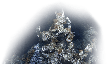
In 2016, the DDL was redesigned weighing two tonnes and measuring six meters in length.
The power of turbidity currents is an ongoing area of important interest globally for not only the science community, but also industry due to the potential for these rapid downhill flows to disrupt critical undersea infrastructure, such as telecommunications cables.
Critical infrastructure within the Fraser delta includes a major passenger ferry terminal and a bustling port facility built on the edge of the mudflat; subsea cables run across the slope supplying telecommunications to Vancouver Island from Lower Mainland BC.
The power of underwater landslides
In 2012, the underwater laboratory was hit by a turbidity current harder than anyone could have expected, sending the DDL tumbling 75 metres down the slope and breaking it free from the cable connection. The unprecedented event captured never before seen data, resulting in several peer-reviewed publications and garnering international attention.
Deployed at depths along the Delta front ranging from 45 metres to over 100 metres, NRCan and ONC engineers completed three iterations of the DDL to withstand the power of the turbidity flows. Additionally, other seabed penetrating probes were deployed as part of the DDL suite of instruments specifically designed to measure fluid pressures differentials between the delta sediment and the overlying water, and thus calculate fluid flows and slope stabilities.
Tsunami hypothesis
Open-source data shared by ONC with the Canadian Geological Survey (CGS), a branch of NRCan, contributed directly to federal public safety programs which seek to understand natural hazards, climate change and geoscience.
GSC researchers at the outset of the project were particularly interested in testing a hypothesis that a major earthquake would trigger a massive landslide along the Delta front large enough to potentially trigger a tsunami as high as 18 metres offshore.
Fortunately, no evidence from the past 14 years of either the DDL deployment, or the ancillary work conducted on the ONC cruises, demonstrated that a submarine landslide of this magnitude could ever occur in this area, though smaller ones have been observed from time to time where the river piles up its sediment loads.
The data retrieved from the underwater laboratory will continue to inform future research initiatives for many years to come.
Lintern, reflects, "this end of the NRCan DDL cabled infrastructure is a very poignant moment for me. It has been more than half a career of effort and has produced some of the most exciting innovative science we have done here at the GSC Pacific. It has also boosted Canada’s reputation in this field among European and American researchers."